Randonnée V.T.T. Le Bonhomme - Bagenelles- tour Grande Roche - Photo

Bagenelles- tour Grande Roche

 berruyer
berruyer

Utilisateur

© OpenStreetMap contributors
Longueur
Longueur
25 km
Altitude max
Altitude max
1047 m
Dénivelé positif
Dénivelé positif
796 m
Km-Effort
Km-Effort  
36 km
Altitude min
Altitude min
664 m
Dénivelé négatif
Dénivelé négatif
797 m
Boucle
Boucle
Oui
Date de création :
2024-08-05 08:33:49.0
Dernière modification :
2024-08-05 12:53:37.719

(0 Avis)

V.T.T.
V.T.T.
2h47
Difficulté : Moyen

Scannez ce code QR pour ouvrir la randonnée dans l'application SityTrail

Application GPS de randonnée GRATUITE

Logo SityTrail SityTrail

IGN / Instituts géographiques

Télécharger SityTrail sur l'App Store Télécharger SityTrail sur Google Play

Logo SityTrail SityTrail World

Le monde est à vous

Télécharger SityTrail sur l'App Store Télécharger SityTrail sur Google Play Télécharger SityTrail sur Huawei AppGallery

À propos

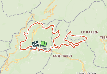
Randonnée V.T.T. de 25 km à découvrir à Grand Est, Haut-Rhin, Le Bonhomme. Cette randonnée est proposée par berruyer.

Description

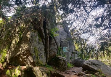
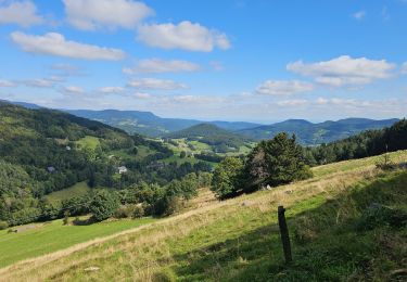
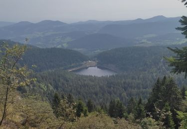
Joli tour avec de très belles vues, sans difficultés 764m dénivelé positive

Profil altimétrique

Localisation

Pays :
France
Région :
Grand Est
Département/Province :
Haut-Rhin
Commune :
Le Bonhomme
Localité :
Unknown
Départ:(Dec)
Départ:(UTM)
359976 ; 5337037 (32U) N.

Randonnées à proximité

Randonnée Marche Le Bonhomme - Tête des faux . - Photo
Marche
heurtinpatrick

Marche

Moyen
(1)
Le Bonhomme, Grand Est, Haut-Rhin, France
11,9 km | 16,6 km-effort
3h 46min
Oui
Randonnée Marche Lapoutroie - 2012-06-16 Marche aux Alisiers Orbey - Photo
Marche
GUIDE
holtzv

Marche

Facile
(2)
Lapoutroie, Grand Est, Haut-Rhin, France
11,1 km | 16,6 km-effort
2h 49min
Oui
Randonnée V.T.T. Orbey - Lac Blanc  - Têtes des Faux - Photo
V.T.T.
tracegps

V.T.T.

Moyen
(1)
Orbey, Grand Est, Haut-Rhin, France
15,3 km | 21 km-effort
1h 0min
Oui
Randonnée Marche Le Bonhomme - Le Bonhomme - Circuit du village - Photo
Marche
GUIDE
Desrumaux

Marche

Facile
(1)
Le Bonhomme, Grand Est, Haut-Rhin, France
3 km | 5,3 km-effort
1h 30min
Oui
Randonnée Marche Sainte-Marie-aux-Mines - 2021-02-14 Marche Bagenelles Brezouard Fuste de Etoile - Photo
Marche
GUIDE
holtzv

Marche

Très difficile
Sainte-Marie-aux-Mines, Grand Est, Haut-Rhin, France
17,1 km | 27 km-effort
6h 6min
Oui
Randonnée Marche Lapoutroie - 2020-07-19 Marche Étang du Devin Col Calvaire Tête des Faux - Photo
Marche
GUIDE
holtzv

Marche

Très facile
Lapoutroie, Grand Est, Haut-Rhin, France
14,2 km | 22 km-effort
3h 27min
Oui
Randonnée Marche Orbey - Orbey-Labaroche - Photo
Marche
ilur56

Marche

Facile
(1)
Orbey, Grand Est, Haut-Rhin, France
13,7 km | 21 km-effort
4h 17min
Oui
Randonnée V.T.T. Orbey - Welche E Bike Tour 2024 - Photo
V.T.T.
duchaine.nicolas

V.T.T.

Moyen
Orbey, Grand Est, Haut-Rhin, France
35 km | 51 km-effort
2h 17min
Oui
Randonnée Marche Orbey - Col du Calvaire ➡️ Lac Blanc  - Photo
Marche
nana1643

Marche

Moyen
Orbey, Grand Est, Haut-Rhin, France
8,6 km | 12,8 km-effort
3h 9min
Oui


Fermer
Mes abonnements